The flooding along the Texas and Louisiana border is undoubtedly no big national story. That is because, perhaps, a half-million people reside there as opposed to larger metro areas. The same limited media coverage also happened in this part of the U.S. during Hurricanes Rita and Ike. Sure there were the TV people who parachuted in and got their “Dan Rather” routine, trying to stand up in the wind and rain while talking. I imagine some of these folks could even chew gum at the same time.
But have no doubt this flooding is affecting millions of people merely because the flood waters in the Sabine River between Texas and Louisiana has submerged Interstate 10. Texas transportation officials say it could be Tuesday or later until it is reopened.
The most recent Texas Department of Transportation (TxDOT) figures, that I could find after an hour of searching, from 2013 shows about 48,500 automobiles travel I-10 just outside the southwestern Beaumont city limit. Houston, the nation’s fourth-largest city is, mostly, west from there some 75-to-80 miles. Near where Interstate 10 intersects with what are basically three highways in Beaumont — US 69, US 96 and US 287 — more than 130,000 vehicles travel per day. On about 25 miles east, at the Texas-Louisiana border, the traffic count is about 46, 000. You talk about cars, trucks, buses to the Louisiana casinos, and so forth going here and there, that is a lot of people.
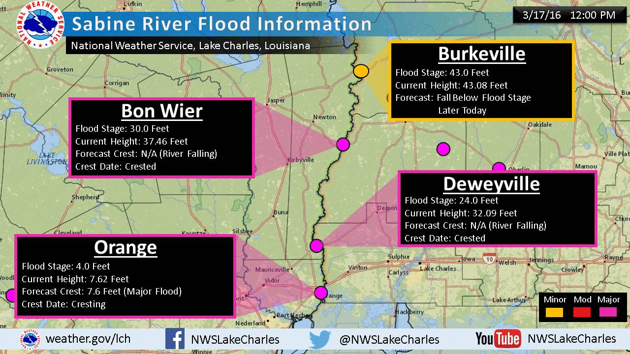
The flooding at the I-10 bridge at the Texas border in Orange — that city was devastated from storm surge in 2008 from Hurricane Ike and now may see even worse flooding — was the scene Wednesday of confusion between the two states and no doubt left much head-scratching among those in the more than 46,000 vehicles which head east and west.
It is really difficult to keep up with the confusing details of the I-10 closures at the Texas-Louisiana border. Wednesday morning, TxDOT was supposedly poised to close the Sabine River bridge. The Louisiana State Police did close the westbound lanes to the bridge. But the eastbound routes remained open, for awhile at least. Returning from Houston yesterday on I-10, I saw probably five or six electronic signs that warned the bridge was completely closed, in both directions.
Amid this confusion, TxDOT issued some I-10 alternate route information that made me wonder if the information was clear enough for the average driver who does not live in this part of the state, or even if they are from elsewhere.
- El Paso take I-20 East of Van Horn
- San Antonio take I-35 North to I-20 East to Shreveport
- Houston take US 59 North to I-20 East to Shreveport
- Beaumont take US 96 North to US 69 North to US 59 North to I-20 East to Shreveport
At least the last alternative made apprehensive. US 96 to 69 — remember they are considered the same along with US 287 going northward from Beaumont. That is really no problem but I think the transportation department might have added: In Lufkin, turn right on Loop 287 and take the US 59 exit toward Nacogdoches. Trust me, I lived in Nacogdoches for many years and those directions are seared in my brain.
All of those alternatives were not meant for me, of course. I think later, when the Sabine River bridge was opened on US 190 in Bon Wier, Texas, TxDOT gave the alternative to travel up US 96 to US 190 in Jasper, from where the state line is about 25 miles east to southeast on that highway toward Baton Rouge.
I worked today so maybe I didn’t read everything about traffic on I-10 that I needed to. I was quite surprised though when heading to downtown Beaumont this morning where I-10 was reduced from three lanes to one lane. It turned out, I didn’t even have the option of going on east to downtown. Traffic was being rerouted at the I-10 split with US 69/96/287. I found a way off and made my on alternate route to downtown. I wish I had known that I couldn’t drive on the interstate the way I usually do. To be fair, I had to go out westbound on I-10 later on, and coming home I saw that an electric sign message said that the interstate would be closed at the exit where the routes to the Piney Woods split.
These are all minor inconveniences to me. The majority of the area hit hardest on the Texas side of the Sabine is where I grew up and where my closest relatives and old friends still reside. Several family members are working to keep others safe. One of those — a niece — is helping others even though she and her family had to be rescued by military personnel. Hopes for her home surviving are dismal, from the last messages I have seen.
This is, literally, a disaster. A large portion of this area in Texas has been declared a disaster area by the state. Gov. Greg Abbott, the Republican executive of Texas, flew over the region in a chopper. I am hopeful President Obama will also declare these counties as a disaster area.
Looking at such wreckage makes you forget your own minor problems — like some traffic slow-down. I do hope TxDOT will learn from their mistakes and miscues. Obviously, Texas and our neighbor to the east need better communication.
Spelling error report
The following text will be sent to our editors: